Alla fine l'inverno 2017 potrebbe chiudere con +0.4 dicembre 1.11 e Gennaio - 1.67 ° C e Febbraio con + 1.5 o 1.7.IMadeYouReadThis ha scritto:Ha chiuso a +1,10 dalla 71/00. Sicuramente freddo non è statorobert ha scritto: in realta , su base 1981/2010 ,
in questo grafico , in Italia non sembra che dicembre 2016 sia stato nel complesso mite , Mite al nord ,
invece al centro sud inferiore la media tra - 0,5 e 1 grado
http://models.weatherbell.com/climate/n ... 122016.png
Enso 2017/2018
Moderatori: erboss, MeteoLive, jackfrost
-
Burian2012

- *Forumista TOP*
- Messaggi: 9040
- Iscritto il: gio mar 08, 2012 3:44 pm
- Località: Melfi
-
Blizzard90A
- Forumista senior
- Messaggi: 7917
- Iscritto il: dom gen 06, 2013 12:22 pm
- Località: Genzano di Roma 450 mt
Hmm secondo me anche +2 e oltre, ora arriva la +10 e la prima decade è stata veramente mostruosa, dubito fortemente che il mese riesca a chiudere sotto i +2Burian2012 ha scritto:Alla fine l'inverno 2017 potrebbe chiudere con +0.4 dicembre 1.11 e Gennaio - 1.67 ° C e Febbraio con + 1.5 o 1.7.IMadeYouReadThis ha scritto:Ha chiuso a +1,10 dalla 71/00. Sicuramente freddo non è statorobert ha scritto: in realta , su base 1981/2010 ,
in questo grafico , in Italia non sembra che dicembre 2016 sia stato nel complesso mite , Mite al nord ,
invece al centro sud inferiore la media tra - 0,5 e 1 grado
http://models.weatherbell.com/climate/n ... 122016.png
-
Burian2012
- *Forumista TOP*
- Messaggi: 9040
- Iscritto il: gio mar 08, 2012 3:44 pm
- Località: Melfi
Vedremo ormai maca poco ai dati ufficiali.Blizzard90A ha scritto:Hmm secondo me anche +2 e oltre, ora arriva la +10 e la prima decade è stata veramente mostruosa, dubito fortemente che il mese riesca a chiudere sotto i +2Burian2012 ha scritto:Alla fine l'inverno 2017 potrebbe chiudere con +0.4 dicembre 1.11 e Gennaio - 1.67 ° C e Febbraio con + 1.5 o 1.7.IMadeYouReadThis ha scritto: Ha chiuso a +1,10 dalla 71/00. Sicuramente freddo non è stato
-
Blizzard90A
- Forumista senior
- Messaggi: 7917
- Iscritto il: dom gen 06, 2013 12:22 pm
- Località: Genzano di Roma 450 mt
Aggiorniamo l'enso allora:luca90 ha scritto:Dalla QBO al comportamento Termico dell'inverno 2017 in un Post che dovrebbe aggiornare l'Enso...
 image hosting
 image share
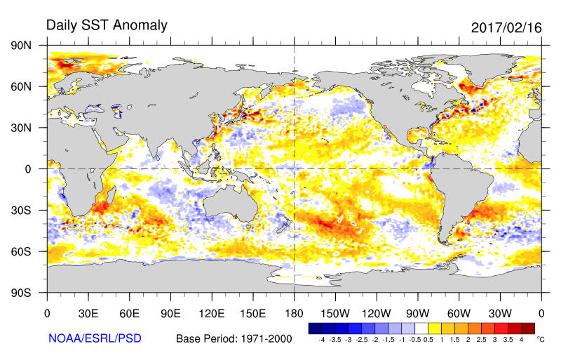
-
furia atlantica
- Messaggi: 2686
- Iscritto il: gio set 06, 2012 2:29 pm
- Località: Asti
ormai l' intero pianeta è assediato da anomalie oceaniche positive, io la butto lì, ma non è che quello che noi chiamiamo nino in realtà è ormai la temperature "neutra "dell' oceano? NOn so se mi spiegoluca90 ha scritto:Le SSTA con lo sguardo sopratutto al comparto Pacifico che mostra come questo sia "caldo"
-
luca90

- *Forumista TOP*
- Messaggi: 27049
- Iscritto il: lun gen 26, 2009 8:32 pm
- Località: Capiago Intimiano (CO)
Indubbiamente gli ultimi anni hanno visto un aumento Termico anche a livello Oceanico. Il GW e le varie fasi Enso+/++ hanno non poco che aumentato lo scarto rispetto la media di monitoraggio ma per la valutazioni dell'anomalia Enso i vari centri optano gia sistemi di calcolo per individuare la corretta anomalia.
Uno degli aspetti da considerare è anche quello per cui gli Oceani rilasciano calore ma il dubbio permane sulla possibilità che questo calore venga effettivamente scaricato...
Uno degli aspetti da considerare è anche quello per cui gli Oceani rilasciano calore ma il dubbio permane sulla possibilità che questo calore venga effettivamente scaricato...
-
luca90
- *Forumista TOP*
- Messaggi: 27049
- Iscritto il: lun gen 26, 2009 8:32 pm
- Località: Capiago Intimiano (CO)
L'aggiornamento BOM comincia anche lui a propendere per una fase Enso+ nel corso dei prossimi mesi. Tuttavia nella breve lettura che viene fornita viene indicata la particolare prudenza in questo periodo dell'anno nel dichiarare una tendenza in questo campo affidabile. "l'orologio" Enso scatta verso il Nino, le percentuali si sono alzate e il Pacifico Centrale ha subito un'ulteriore riscaldamento. Il SOI invece è andato a solleticare i -2 di valore.
"The El Niño-Southern Oscillation (ENSO) remains neutral. However, recent changes in both the tropical Pacific Ocean and atmosphere, and climate model outlooks surveyed by the Bureau, suggest the likelihood of El Niño forming in 2017 has risen. As a result, the Bureau's ENSO Outlook status has been upgraded to El Niño WATCH, meaning the likelihood of El Niño forming in 2017 is approximately 50%.
All atmospheric and oceanic indicators of ENSO are currently within neutral thresholds. However, sea surface temperatures have been increasing in the eastern Pacific Ocean and are now warmer than average for the first time since June 2016, while the Southern Oscillation Index (SOI) has been trending downwards.
Seven of eight international models surveyed by the Bureau indicate steady warming in the central tropical Pacific Ocean over the next six months. Six models suggest El Niño thresholds may be reached by July 2017. However, some caution must be taken at this time of year, with lower model accuracy through the autumn months compared to other times of the year.
El Niño is often associated with below average winter–spring rainfall over eastern Australia and warmer than average winter–spring maximum temperatures over the southern half of Australia."
Grandissimo luca un saluto  Beh, in effetti se si guardano gli aggiornamenti delle SSTA unisys, si nota perfettamente un anomalo riscaldamento delle acque del Perù, che di solito precede lo sviluppo di un evento di El Nino. Aggiungo un'osservazione del tutto personale: sarà una pura coincidenza, ma è interessante notare come l'anomala, mancata inversione della QBO si sia tradotta prima in uno sviluppo molto limitato de La Nina, e ora in una condizione che lascia prevedere un ritorno di El Nino.
Intendo dire, non è che niente niente i due fattori sono tra loro legati?
Intendo dire, non è che niente niente i due fattori sono tra loro legati?
-
Gabriele95
- Messaggi: 2529
- Iscritto il: mer set 14, 2016 6:31 pm
- Località: Reggio Emilia
Non penso al NINO, la primavera molte volte inganna, anzi il prox inverno sembra torni la nina
 free image upload
 caricare immagini
free image uploadcaricare immagini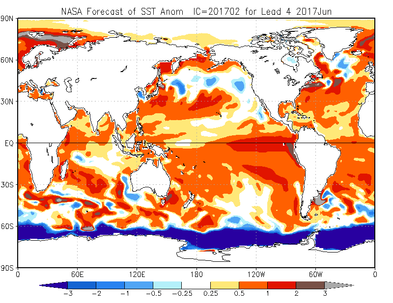
-
Blizzard90A
- Forumista senior
- Messaggi: 7917
- Iscritto il: dom gen 06, 2013 12:22 pm
- Località: Genzano di Roma 450 mt
El Nino entro la primavera è confermato da quanto vedo, in caso venisse confermato questo rimescolerebbe decisamente le carte per l'estate, anche se non è detto riesca a condizionare in tempo gli alisei indebolendoli e quindi ovviamente l'ITF, ovviamente andranno monitorati altri indici importanti come lo IOD.luca90 ha scritto:@Terremoto, l'Enso++ 2015/2016 secondo alcune ricerche sembrerebbe aver avuto una sorte di effetto sull'andamento "lineare" della QBO.
El Nino Est based per Nasa in Giugno 2017
vedremo nel prossimo aggiornamento.