Peggioramento: focus Lazio
Moderatori: erboss, MeteoLive, jackfrost


-
pubblico
Incredibile aggiornamento di estofex!!!

I sospetti che tutto potesse andare più a est erano fondati!!!
The main reson for this update was a significant expansion of the level 2.
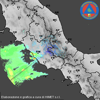
A training band of showers and thunderstorms was present west of Sardinia during the day and finally evolved into an huge convective cluster, which now affects Corsica and thereafter ought to reach the coast of NW-Italy during the early night hours. Latest data suggests a gradual weakening of this cluster but the atmosphere is supportive for re-development over the Ligurian Sea. The level 1 was expanded northwards to highlight the panoramica flood risk. Embedded thunderstorms can occur well inland over NW-Italy and increase the rainfall amounts.
The risk for severe flooding gradually increases along the west-central coast of Italy during the upcoming hours. An healthy looking cluster of storms is currently developing east of Sardinia and will affect central Italy during the following hours. Dewpoints along the coast are in the upper tens / lower twenties and the 12 UTC sounding already reveals a favorable sheared and unstable environment. Next to the flood risk, large hail, severe wind gusts and tornadoes are all possible.
I sospetti che tutto potesse andare più a est erano fondati!!!
The main reson for this update was a significant expansion of the level 2.
A training band of showers and thunderstorms was present west of Sardinia during the day and finally evolved into an huge convective cluster, which now affects Corsica and thereafter ought to reach the coast of NW-Italy during the early night hours. Latest data suggests a gradual weakening of this cluster but the atmosphere is supportive for re-development over the Ligurian Sea. The level 1 was expanded northwards to highlight the panoramica flood risk. Embedded thunderstorms can occur well inland over NW-Italy and increase the rainfall amounts.
The risk for severe flooding gradually increases along the west-central coast of Italy during the upcoming hours. An healthy looking cluster of storms is currently developing east of Sardinia and will affect central Italy during the following hours. Dewpoints along the coast are in the upper tens / lower twenties and the 12 UTC sounding already reveals a favorable sheared and unstable environment. Next to the flood risk, large hail, severe wind gusts and tornadoes are all possible.
-
blizzard90

- Messaggi: 1325
- Iscritto il: lun gen 26, 2009 9:55 pm
- Località: Roma
-
blizzard90
- Messaggi: 1325
- Iscritto il: lun gen 26, 2009 9:55 pm
- Località: Roma
